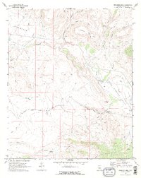
1969 Map of Bismarck Mesa
USGS Topo · Published 1972About this map
The Atchison Topeka and Santa Fe railroad cuts across the high desert terrain of Yavapai County, connecting the small settlement of Grand View to the broader regional network. The landscape transitions from the southern foothills of the Weaver Mountains northward into the broad expanse of the Lower Kirkland Valley. Significant elevation changes are marked by Bismarck Mesa and the prominent Squaw Peak, while the drainage system of Kirkland Creek and its tributaries like Alkali Wash define the water-scarce environment. Local history is grounded in small outposts like Ritter and Bland, and the presence of a lone Cem and scattered prospects suggests the legacy of early ranching and mining efforts. Essential water sources for this arid region are carefully noted, including Bells Spring and Red Bank Spring, which sustained life between the rugged canyons and desert valleys.
Find a feature on this map
33 named features on this map. Tap any name to fly to it.
Don’t see what you’re looking for? This feature index may not catch every label — zoom into the map to look around manually.
Map Details
Editions of this 1969 Bismarck Mesa Map
2 editions found
Other maps of this area

1887 · Prescott
USGS Topo · 1:250,000

1892 · Prescott
USGS Topo · 1:250,000

1903 · Congress
USGS Topo · 1:125,000

1904 · Congress
USGS Topo · 1:125,000

1947 · Iron Springs
USGS Topo · 1:62,500

1947 · Kirkland
USGS Topo · 1:62,500

1947 · Sheridan Mountain
USGS Topo · 1:62,500

1948 · Sheridan Mountain
USGS Topo · 1:63,360

1948 · Iron Springs
USGS Topo · 1:63,360

1948 · Kirkland
USGS Topo · 1:63,360