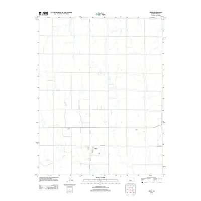
2012 Map of Bison
USGS Topo · Published 2012About this map
Bison sits at the heart of this Rush County landscape, where the local street grid is defined by N Front St, Main St, and E 2nd St. The town's civic life is anchored by a Po, serving a rural community that extends across the section lines of the central Kansas prairie. The surrounding agricultural lands are etched by several intermittent drainage systems, including the southward-winding Shelter Cr, Duck Cr to the east, and Sand Cr which meanders through the southern sections near CO Hwy-584. The placement of numerous community burial grounds, such as Lone Star Cem and the Baptist Cem, indicates a deep-rooted pattern of settlement and social organization across the township. Further east, the Seventh Day Adventist Cem reflects the distinct denominational history common to this part of the Great Plains.
Find a feature on this map
14 named features on this map. Tap any name to fly to it.
Don’t see what you’re looking for? This feature index may not catch every label — zoom into the map to look around manually.
Map Details
Editions of this 2012 Bison Map
This is the sole edition of this map. No revisions or reprints were ever made.
Other maps of this area

1889 · Larned
USGS Topo · 1:125,000

1891 · Larned
USGS Topo · 1:125,000

1896 · Hays
USGS Topo · 1:125,000

1955 · Great Bend
USGS Topo · 1:250,000

1957 · Great Bend
USGS Topo · 1:250,000

1958 · Great Bend
USGS Topo · 1:250,000
1965 · Otis
USGS Topo · 1:24,000
1965 · Albert
USGS Topo · 1:24,000

1966 · Rush Center
USGS Topo · 1:24,000

1966 · La Crosse
USGS Topo · 1:24,000