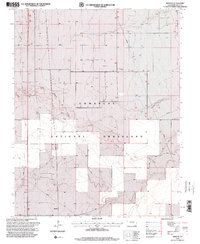
1996 Map of Bisonte
USGS Topo · Published 2000About this map
Comanche National Grassland dominates this landscape in Baca County, where the topography is defined by the intermittent drainage of Lone Rock Draw, Dry Creek, and Sand Arroyo. The settlement of Bisonte sits in the southwestern portion of the sheet, serving as a focal point in a region characterized by sparse water resources and a dependence on subsurface access. A network of wells, including the specifically named Big Bankiter Well, is mapped throughout the township and range grid, illustrating the vital role of water infrastructure for cattle and agriculture in this semi-arid high plains environment. The presence of a Communication Tower and a significant Pipeline corridor crossing the terrain reflects the mid-to-late 20th-century modernization of this remote landscape, even as many roads remain primitive 4wd tracks.
Find a feature on this map
13 named features on this map. Tap any name to fly to it.
Don’t see what you’re looking for? This feature index may not catch every label — zoom into the map to look around manually.
Map Details
Editions of this 1996 Bisonte Map
This is the sole edition of this map. No revisions or reprints were ever made.
Other maps of this area

1891 · Springfield
USGS Topo · 1:125,000

1892 · Vilas
USGS Topo · 1:125,000

1893 · Springfield
USGS Topo · 1:125,000

1955 · La Junta
USGS Topo · 1:250,000

1958 · La Junta
USGS Topo · 1:250,000

1968 · La Junta
USGS Topo · 1:250,000

1978 · Springfield SW
USGS Topo · 1:24,000

1978 · Campo NE
USGS Topo · 1:24,000
1978 · Bisonte
USGS Topo · 1:24,000
1978 · Vilas North
USGS Topo · 1:24,000