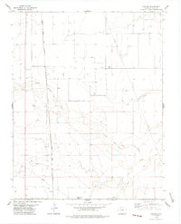
1978 Map of Bisonte
USGS Topo · Published 1978About this map
Bisonte serves as a small point of reference in this arid stretch of Baca County, where the plains are defined by ephemeral watercourses and deep-cut drainage patterns. The Atchison Topeka and Santa Fe railroad cuts a straight north-south line through the landscape, anchoring the region's transport network during the late 1970s. This survey illustrates the sparse, high-plains settlement pattern of the era, where named landmarks are often vital water sources like Big Bankiter Well or distinctive terrain features such as Lone Rock Draw and Sand Arroyo. A massive network of subsurface infrastructure is also evident, with multiple Pipeline corridors traversing the sections, reflecting the region's mid-century energy development alongside traditional ranching and rail interests.
Find a feature on this map
13 named features on this map. Tap any name to fly to it.
Don’t see what you’re looking for? This feature index may not catch every label — zoom into the map to look around manually.
Map Details
Editions of this 1978 Bisonte Map
This is the sole edition of this map. No revisions or reprints were ever made.
Other maps of this area

1891 · Springfield
USGS Topo · 1:125,000

1892 · Vilas
USGS Topo · 1:125,000

1893 · Springfield
USGS Topo · 1:125,000

1955 · La Junta
USGS Topo · 1:250,000

1958 · La Junta
USGS Topo · 1:250,000

1968 · La Junta
USGS Topo · 1:250,000

1978 · Springfield SW
USGS Topo · 1:24,000

1978 · Campo NE
USGS Topo · 1:24,000
1978 · Vilas North
USGS Topo · 1:24,000
1978 · Springfield West
USGS Topo · 1:24,000