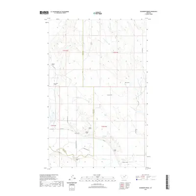
2020 Map of Bjornberg Bridge
USGS Topo · Published 2020About this map
Milk River and its complex network of coulees and springs dominate this portion of the northern plains along the Phillips Co Valley Co border. The river valley is a focal point of activity, featuring the namesake crossing at Bjornberg Bridge and a series of agricultural roads including Milk River Rd and June Bjornberg Bridge Rd. The landscape is deeply incised by drainage features like Bücher Coulee, Stevens Coulee, and Smith Coulee, which define the local topography.
Find a feature on this map
34 named features on this map. Tap any name to fly to it.
Don’t see what you’re looking for? This feature index may not catch every label — zoom into the map to look around manually.
Map Details
Editions of this 2020 Bjornberg Bridge Map
This is the sole edition of this map. No revisions or reprints were ever made.
Other maps of this area

1905 · Saco Special
USGS Topo · 1:62,500

1906 · Hinsdale Special Map
USGS Topo · 1:62,500

1954 · Glasgow
USGS Topo · 1:250,000

1957 · Glasgow
USGS Topo · 1:250,000

1958 · Glasgow
USGS Topo · 1:250,000

1984 · Bjornberg Bridge
USGS Topo · 1:24,000

1984 · Double S Hill
USGS Topo · 1:24,000
1984 · Jones Coulee
USGS Topo · 1:24,000
1984 · Saco
USGS Topo · 1:24,000
1984 · Papoose Hills
USGS Topo · 1:24,000