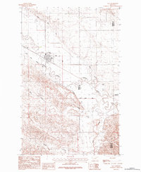
1984 Map of Saco
USGS Topo · Published 1984About this map
Saco serves as the primary hub in this portion of the northern plains, where the grid of the town site meets the meandering path of Beaver Creek. The landscape is defined by an extensive water management system, most notably the Nelson South Number 9 Canal, which winds through the territory to support agricultural interests. Near the town center, a Cem and various G W sites suggest the intersection of community life and local industry during the mid-1980s. Further east, the small settlement of Beaverton sits near the border of Phillips and Valley Counties. The southern portion of the map transitions into a more dissected terrain where First Creek, Second Creek, and Larb Creek drain toward the larger Beaver Creek valley, illustrating the natural drainage patterns that have shaped movement and settlement in this Montana region.
Find a feature on this map
10 named features on this map. Tap any name to fly to it.
Don’t see what you’re looking for? This feature index may not catch every label — zoom into the map to look around manually.
Map Details
Editions of this 1984 Saco Map
This is the sole edition of this map. No revisions or reprints were ever made.
Other maps of this area

1905 · Saco Special
USGS Topo · 1:62,500

1906 · Hinsdale Special Map
USGS Topo · 1:62,500

1954 · Glasgow
USGS Topo · 1:250,000

1957 · Glasgow
USGS Topo · 1:250,000

1958 · Glasgow
USGS Topo · 1:250,000

1984 · Cole
USGS Topo · 1:24,000

1984 · Bjornberg Bridge
USGS Topo · 1:24,000
1984 · Robinson Ranch
USGS Topo · 1:24,000

1984 · Double S Hill
USGS Topo · 1:24,000

1984 · Ashford Coulee
USGS Topo · 1:24,000