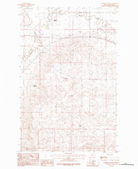
1984 Map of Robinson Ranch
USGS Topo · Published 1984About this map
Robinson Ranch serves as a primary landmark in this ranching landscape of Phillips County, where the plains are etched by a complex network of seasonal drainages and irrigation infrastructure. The movement of water is central to life here, as evidenced by the Nelson South Canal and the presence of the Ashfield Reservoir and PR 40 Reservoir. These features, along with the meandering course of Beaver Creek, illustrate the engineered efforts to manage the semi-arid environment for livestock and agricultural use. Near the settlement of Ashfield, the terrain is defined by low-lying coulees like Hay Coulee and Thomas Coulee, which lead toward the higher ground of the Palisade. This 1984 provisional survey captures the distribution of remote ranch steadies and the essential waterways of the high plains, including First Creek and Second Creek, before later developments altered the local topography.
Find a feature on this map
12 named features on this map. Tap any name to fly to it.
Don’t see what you’re looking for? This feature index may not catch every label — zoom into the map to look around manually.
Map Details
Editions of this 1984 Robinson Ranch Map
This is the sole edition of this map. No revisions or reprints were ever made.
Other maps of this area

1905 · Bowdoin
USGS Topo · 1:62,500

1905 · Saco Special
USGS Topo · 1:62,500

1920 · Cowan
USGS Topo · 1:125,000

1954 · Glasgow
USGS Topo · 1:250,000

1957 · Glasgow
USGS Topo · 1:250,000

1958 · Glasgow
USGS Topo · 1:250,000
1968 · Hewitt Lake
USGS Topo · 1:24,000

1984 · Cole
USGS Topo · 1:24,000

1984 · Pinks
USGS Topo · 1:24,000

1984 · Double S Hill
USGS Topo · 1:24,000