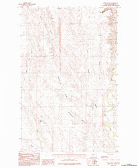
1984 Map of Jones Coulee
USGS Topo · Published 1984About this map
Windy Ridge and the complex drainage systems of Valley County define this 1980s landscape, where water management is central to the terrain's utility. The area is marked by a series of small-scale impoundments including Erie Reservoir, Swift Reservoir, York Reservoir, and Bud Reservoir, likely serving as critical stock water sources for local ranching operations. The topography is shaped by numerous intermittent coulees, such as Norwegian Coulee, Jones Coulee, and Sheepherders Coulee, which channel seasonal runoff toward the more prominent Rock Creek and its associated Rock Creek Canyon. The prevalence of named coulees and small reservoirs reflects a landscape meticulously adapted for agricultural endurance in the semi-arid northern plains. Traces of human engineering are further evidenced by Levees along Papoose Creek, protecting lower-lying ground from the unpredictable surges of prairie watercourses.
Find a feature on this map
19 named features on this map. Tap any name to fly to it.
Don’t see what you’re looking for? This feature index may not catch every label — zoom into the map to look around manually.
Map Details
Editions of this 1984 Jones Coulee Map
This is the sole edition of this map. No revisions or reprints were ever made.
Other maps of this area

1906 · Hinsdale Special Map
USGS Topo · 1:62,500

1919 · Boundary
USGS Topo · 1:125,000

1943 · Glasgow
USGS Topo · 1:125,000

1954 · Glasgow
USGS Topo · 1:250,000

1957 · Glasgow
USGS Topo · 1:250,000

1958 · Glasgow
USGS Topo · 1:250,000

1969 · Ellsworth Coulee
USGS Topo · 1:24,000

1984 · Bjornberg Bridge
USGS Topo · 1:24,000

1984 · Opheim
USGS Topo · 1:100,000
1984 · Glasgow
USGS Topo · 1:100,000