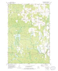
1973 Map of Black Brook
USGS Topo · Published 1976About this map
The Ackley State Wildlife Areas dominate the southern landscape of this Langlade County region, showcasing a complex network of wetlands and managed natural spaces in the early 1970s. This survey captures a moment when the transition from agricultural land to conservation and recreational use was clearly visible, with the terrain defined by the headwaters of the Pine River and the Trappe River. To the north, the Vilas Lookout Tower stands as a prominent topographical landmark, while the small settlement of Townhall serves as a local civic center.
Find a feature on this map
23 named features on this map. Tap any name to fly to it.
Don’t see what you’re looking for? This feature index may not catch every label — zoom into the map to look around manually.
Map Details
Editions of this 1973 Black Brook Map
This is the sole edition of this map. No revisions or reprints were ever made.
Other maps of this area

1899 · Wausau
USGS Topo · 1:125,000

1902 · Wausau
USGS Topo · 1:125,000

1940 · Parrish
USGS Topo · 1:48,000

1942 · Elcho
USGS Topo · 1:48,000

1950 · Elcho
USGS Topo · 1:48,000

1950 · Parrish
USGS Topo · 1:48,000

1951 · Doering
USGS Topo · 1:48,000

1952 · Parrish
USGS Topo · 1:48,000

1952 · Antigo
USGS Topo · 1:48,000

1954 · Iron Mountain
USGS Topo · 1:250,000