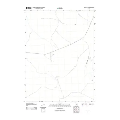
2011 Map of Black Butte
USGS Topo · Published 2011About this map
Curlew Valley defines the eastern expanse of this Box Elder County landscape, where the seasonal drainages of Indian Creek and Tenmile Creek cut through the high desert terrain. The map captures a ranching-focused interior where isolated headquarters like the Morris Ranch and Bar F Ranch serve as primary landmarks in an otherwise open range. Dominating the central-northern portion is the namesake Black Butte, a prominent elevation that provides a rare vertical anchor in the broad valley. A network of rural arteries, including Cedar Creek Rd and N 46000 West Rd, connects these remote outposts, reflecting the enduring grid of Utah's rural infrastructure at the beginning of the 21st century.
Find a feature on this map
10 named features on this map. Tap any name to fly to it.
Don’t see what you’re looking for? This feature index may not catch every label — zoom into the map to look around manually.
Map Details
Editions of this 2011 Black Butte Map
This is the sole edition of this map. No revisions or reprints were ever made.
Other maps of this area

1954 · Brigham City
USGS Topo · 1:250,000

1958 · Brigham City
USGS Topo · 1:250,000

1959 · Kelton Pass
USGS Topo · 1:62,500

1959 · Park Valley
USGS Topo · 1:62,500

1962 · Brigham City
USGS Topo · 1:250,000

1969 · Peplin Flats
USGS Topo · 1:24,000

1969 · Crocodile Mtn NE
USGS Topo · 1:24,000
1971 · Russian Knoll
USGS Topo · 1:24,000

1987 · Grouse Creek
USGS Topo · 1:100,000
1990 · Curlew Junction
USGS Topo · 1:24,000