
1969 Map of Crocodile Mtn NE
USGS Topo · Published 1972About this map
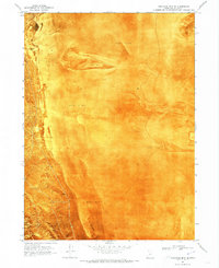
Kelton (Site) stands as a reminder of the transcontinental railroad's path across the harsh landscape of Box Elder County. This 1969 orthophotomap captures the remnants of the Old Central Pacific Grade as it cuts across the expansive Mud Flat north of Crocodile Mountain. The presence of a Cem and landmarks like Wheeler and Flowing Well highlight the sparse but essential infrastructure that once supported life along this historical rail corridor. The orthophoto format provides a unique visual of the terrain's texture, showing how human engineering like the railroad grade interacts with the natural alkaline flats and salt crusts of northern Utah. Researchers can use this document to trace the exact alignment of the pioneer rail route through this desolate region.
Find a feature on this map
10 named features on this map. Tap any name to fly to it.
Don’t see what you’re looking for? This feature index may not catch every label — zoom into the map to look around manually.
Map Details
Editions of this 1969 Crocodile Mtn NE Map
This is the sole edition of this map. No revisions or reprints were ever made.
Other maps of this area

1954 · Brigham City
USGS Topo · 1:250,000

1958 · Brigham City
USGS Topo · 1:250,000

1959 · Kelton Pass
USGS Topo · 1:62,500

1962 · Brigham City
USGS Topo · 1:250,000

1968 · Monument Peak SW
USGS Topo · 1:24,000

1969 · Peplin Flats
USGS Topo · 1:24,000

1969 · Spring Bay SW
USGS Topo · 1:24,000

1969 · Locomotive Springs
USGS Topo · 1:24,000

1969 · Hogup Bar
USGS Topo · 1:24,000
1969 · Crocodile Mtn SE
USGS Topo · 1:24,000