
1959 Map of Kelton Pass
USGS Topo · Published 1960About this map
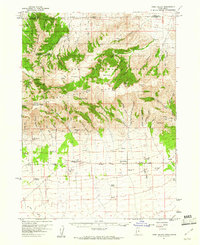
Cedar Creek (Old Stage Station) serves as a waypoint for travelers along the historical corridor crossing the Utah-Idaho state line during the late 1950s. This survey records a landscape defined by isolated family operations such as Vern Steeds Ranch, Morris Ranch, and Bar F Ranch, illustrating the sparse but persistent ranching economy of Curlew Valley. The western edge of the map is dominated by the mountainous terrain of the Sawtooth National Forest, where features like Crystal Peak and Tenmile Ridge overlook deep incisions like Green Canyon. The reliance on natural water sources in this arid basin is evident from the distribution of vital points like Emigrant Spring, Cedar Spring, and Pilot Spring. These springs and numerous Jeep Trails provided the essential infrastructure for movement between the higher elevations and the valley floor.
Find a feature on this map
41 named features on this map. Tap any name to fly to it.
Don’t see what you’re looking for? This feature index may not catch every label — zoom into the map to look around manually.
Map Details
Editions of this 1959 Kelton Pass Map
This is the sole edition of this map. No revisions or reprints were ever made.
Other maps of this area

1954 · Pocatello
USGS Topo · 1:250,000

1954 · Brigham City
USGS Topo · 1:250,000

1958 · Pocatello
USGS Topo · 1:250,000

1958 · Brigham City
USGS Topo · 1:250,000

1959 · Strevell
USGS Topo · 1:62,500
1959 · Park Valley
USGS Topo · 1:62,500

1962 · Brigham City
USGS Topo · 1:250,000
1968 · Monument Peak NW
USGS Topo · 1:24,000
1968 · Monument Peak SW
USGS Topo · 1:24,000
1968 · Naf
USGS Topo · 1:24,000