
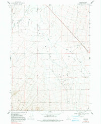
1968 Map of Naf
USGS Topo · Published 1972About this map
Naf sits near the base of the Raft River Valley in this late 1960s study of southern Cassia County. The landscape is defined by the drainage systems of the Raft River and Clear Creek, which descend from the southern heights past Round Mtn. A significant historical footprint is visible in the northeast, where an Old Railroad Grade cuts across the terrain, marking the path of former commerce through this high-desert ranching region. Numerous wells and a isolated Water Tank are scattered throughout the quadrangle, indicating the vital importance of water management for the local area's agricultural and pastoral operations. The presence of several Gravel Pits and various Jeep Trails suggests a landscape utilized for both local resource extraction and utilitarian transit through the valley.
Find a feature on this map
12 named features on this map. Tap any name to fly to it.
Don’t see what you’re looking for? This feature index may not catch every label — zoom into the map to look around manually.
Map Details
Editions of this 1968 Naf Map
2 editions found
Other maps of this area

1954 · Pocatello
USGS Topo · 1:250,000

1954 · Brigham City
USGS Topo · 1:250,000

1958 · Pocatello
USGS Topo · 1:250,000

1958 · Brigham City
USGS Topo · 1:250,000

1959 · Strevell
USGS Topo · 1:62,500

1959 · Kelton Pass
USGS Topo · 1:62,500

1959 · Park Valley
USGS Topo · 1:62,500

1962 · Brigham City
USGS Topo · 1:250,000

1968 · Kane Canyon
USGS Topo · 1:24,000

1968 · Chokecherry Canyon
USGS Topo · 1:24,000