
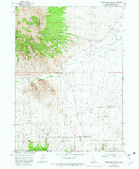
1968 Map of Chokecherry Canyon
USGS Topo · Published 1972About this map
The Raft River Valley dominates this high-desert landscape in Cassia County, where the Raft River cuts through a bottleneck known as The Narrows. This late 1960s survey documents a working landscape of ranching and resource extraction, defined by a network of unimproved roads and several Borrow Pits and Gravel Pits used for local infrastructure. To the west, the Sage Mountains rise sharply, dissected by drainages like Chokecherry Canyon and Womack Canyon, the latter featuring Womack Canyon Spring.
Find a feature on this map
25 named features on this map. Tap any name to fly to it.
Don’t see what you’re looking for? This feature index may not catch every label — zoom into the map to look around manually.
Map Details
Editions of this 1968 Chokecherry Canyon Map
2 editions found
Other maps of this area

1954 · Pocatello
USGS Topo · 1:250,000

1954 · Brigham City
USGS Topo · 1:250,000

1958 · Pocatello
USGS Topo · 1:250,000

1958 · Brigham City
USGS Topo · 1:250,000

1959 · Park Valley
USGS Topo · 1:62,500

1959 · Yost
USGS Topo · 1:62,500

1962 · Brigham City
USGS Topo · 1:250,000

1968 · Jim Sage Canyon
USGS Topo · 1:24,000

1968 · Elba
USGS Topo · 1:24,000

1968 · Kane Canyon
USGS Topo · 1:24,000