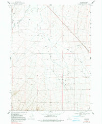
1968 Map of Naf
USGS Topo · Published 1991About this map
Naf serves as the primary point of settlement in this high-desert landscape of Southern Idaho, located just north of the border between Cassia County and Box Elder County, Utah. The terrain is defined by the broad drainage of the Raft River and its various tributaries, including Clear Creek and Rice Creek. A striking historical element on this sheet is the Old Railroad Grade cutting diagonally across the northeastern portion of the quadrangle, a remnant of a bygone transportation route that bypassed the more rugged southern hills. Numerous groundwater wells and localized sources like Round Mtn Spring near Round Mtn illustrate the vital importance of water management for local ranching and agriculture during the late 1960s. The presence of several Gravel Pits and a Water Tank suggest a localized economy focused on road maintenance and livestock support near the interstate boundary.
Find a feature on this map
17 named features on this map. Tap any name to fly to it.
Don’t see what you’re looking for? This feature index may not catch every label — zoom into the map to look around manually.
Map Details
Editions of this 1968 Naf Map
2 editions found
Other maps of this area

1954 · Pocatello
USGS Topo · 1:250,000

1954 · Brigham City
USGS Topo · 1:250,000

1958 · Pocatello
USGS Topo · 1:250,000

1958 · Brigham City
USGS Topo · 1:250,000

1959 · Strevell
USGS Topo · 1:62,500

1959 · Kelton Pass
USGS Topo · 1:62,500

1959 · Park Valley
USGS Topo · 1:62,500

1962 · Brigham City
USGS Topo · 1:250,000

1968 · Kane Canyon
USGS Topo · 1:24,000

1968 · Naf
USGS Topo · 1:24,000