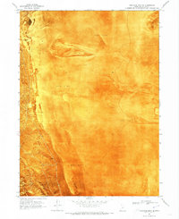
1969 Map of Crocodile Mtn SE
USGS Topo · Published 1973About this map
Mud flats dominate this landscape within the Great Salt Lake desert, where the arid basin floor meets the rising terrain of the Hogup Mts. The 1969 survey, presented as an orthophotomap, reveals the intricate textures of the salt-crusted earth and the sparse distribution of water sources like Spring (Salt). This corner of Box Elder County is defined by the sharp transition between the low-lying expanse of Mud Flat and the foothills of Crocodile Mtn. The topographic data, layered over aerial imagery, provides an exceptional record of the shoreline environment and the faint traces of unimproved roads that navigate the edges of the mountains. This study is particularly valuable for understanding the natural drainage patterns and topographical barriers in a region where water is a critical and infrequent landmark.
Find a feature on this map
6 named features on this map. Tap any name to fly to it.
Don’t see what you’re looking for? This feature index may not catch every label — zoom into the map to look around manually.
Map Details
Editions of this 1969 Crocodile Mtn SE Map
This is the sole edition of this map. No revisions or reprints were ever made.
Other maps of this area

1954 · Brigham City
USGS Topo · 1:250,000

1958 · Brigham City
USGS Topo · 1:250,000

1962 · Brigham City
USGS Topo · 1:250,000

1969 · Peplin Flats
USGS Topo · 1:24,000

1969 · Spring Bay SW
USGS Topo · 1:24,000

1969 · Dolphin Island West
USGS Topo · 1:24,000

1969 · Locomotive Springs
USGS Topo · 1:24,000
1969 · Dolphin Island East
USGS Topo · 1:24,000

1969 · Crocodile Mtn NE
USGS Topo · 1:24,000

1969 · Hogup Bar
USGS Topo · 1:24,000