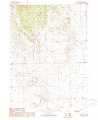
1990 Map of Black Butte
USGS Topo · Published 1990About this map
Raft River Mountains dominate the western portion of this landscape, descending into the broad Curlew Valley to the east. This 1990 survey captures a region defined by its water management and resource extraction, with an aqueduct and several scattered wells supporting activity in an otherwise arid environment. The transition from the high slopes of the mountains to the valley floor is marked by drainage patterns like Indian Creek and Tenmile Creek.
Find a feature on this map
14 named features on this map. Tap any name to fly to it.
Don’t see what you’re looking for? This feature index may not catch every label — zoom into the map to look around manually.
Map Details
Editions of this 1990 Black Butte Map
This is the sole edition of this map. No revisions or reprints were ever made.
Other maps of this area

1954 · Brigham City
USGS Topo · 1:250,000

1958 · Brigham City
USGS Topo · 1:250,000

1959 · Kelton Pass
USGS Topo · 1:62,500

1959 · Park Valley
USGS Topo · 1:62,500

1962 · Brigham City
USGS Topo · 1:250,000

1969 · Peplin Flats
USGS Topo · 1:24,000

1969 · Crocodile Mtn NE
USGS Topo · 1:24,000
1971 · Russian Knoll
USGS Topo · 1:24,000

1987 · Grouse Creek
USGS Topo · 1:100,000
1990 · Curlew Junction
USGS Topo · 1:24,000