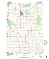
1992 Map of Black Creek
USGS Topo · Published 1996About this map
The village of Black Creek serves as the focal point of this northern Outagamie County landscape, positioned at a significant road junction surrounded by agricultural land and conservation areas. The western edge is dominated by the Mack Wildlife Area, providing a distinct contrast to the grid-work of rural township roads like Brandt Road and Center Valley Road. Smaller settlements such as Binghamton and Twelve Corners are visible, alongside the local waterways of Black Creek and Duck Creek.
Find a feature on this map
32 named features on this map. Tap any name to fly to it.
Don’t see what you’re looking for? This feature index may not catch every label — zoom into the map to look around manually.
Map Details
Editions of this 1992 Black Creek Map
This is the sole edition of this map. No revisions or reprints were ever made.
Other maps of this area

1955 · Embarrass
USGS Topo · 1:48,000

1955 · Appleton
USGS Topo · 1:24,000

1955 · Appleton
USGS Topo · 1:62,500

1955 · Seymour
USGS Topo · 1:62,500

1955 · Green Bay
USGS Topo · 1:250,000

1956 · New London
USGS Topo · 1:48,000

1969 · Leeman
USGS Topo · 1:24,000
1969 · Greenville
USGS Topo · 1:24,000
1969 · Shiocton
USGS Topo · 1:24,000

1974 · Seymour
USGS Topo · 1:24,000