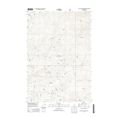
2013 Map of Black Hawk Mountain
USGS Topo · Published 2013About this map
Nez Perce National Forest dominates this Idaho County landscape, showcasing a complex network of canyons and ridgelines defined by the Red River and its numerous tributaries. High points like Black Hawk Mtn and Blue Ribbon Mtn anchor the terrain, while prominent features such as Simmons Ridge and Flatiron Ridge provide significant geographical landmarks. The map reveals an intricate system of Forest Service access roads, including 1189 and 9822, which follow the natural contours of the land to reach more remote drainages like French Gulch and Little Siegel Cr. This 2013 survey reflects the modern management of this backcountry area, where the drainage patterns of Kirks Fork, Galena Cr, and Steckner Cr dictate the movement of both water and traveler through the forested interior.
Find a feature on this map
70 named features on this map. Tap any name to fly to it.
Don’t see what you’re looking for? This feature index may not catch every label — zoom into the map to look around manually.
Map Details
Editions of this 2013 Black Hawk Mountain Map
This is the sole edition of this map. No revisions or reprints were ever made.
Other maps of this area

1956 · Elk City
USGS Topo · 1:250,000

1960 · Elk City
USGS Topo · 1:250,000

1966 · Elk City
USGS Topo · 1:24,000

1966 · Black Hawk Mtn
USGS Topo · 1:24,000

1966 · Lick Point
USGS Topo · 1:24,000

1966 · Sable Hill
USGS Topo · 1:24,000

1966 · Anderson Butte
USGS Topo · 1:24,000
1966 · Vermilion Peak
USGS Topo · 1:24,000

1977 · Boston Mtn
USGS Topo · 1:24,000

1978 · Moose Butte
USGS Topo · 1:24,000