
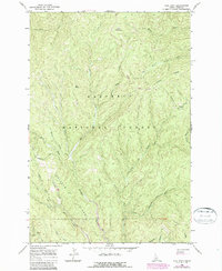
1966 Map of Lick Point
USGS Topo · Published 1968About this map
The Nez Perce National Forest defines the character of this mid-1960s terrain, where the headwaters of the American River and its numerous tributaries carve through the central Idaho landscape. The map provides a clear look at the industrial impact on the mountain environment, specifically near the confluence of Ericson Creek and the American River. Evidence of large-scale mineral processing is visible through labels for a Dredge and substantial Tailings deposits along the riverbanks. This area, largely defined by its drainage systems like Horse Creek and Flint Creek, is navigated by a network of primitive routes marked as Pack Trail and Jeep Trail. High-altitude openings such as Buck Meadows and Marten Meadows serve as distinct landmarks amidst the steep slopes of Ericson Ridge and Flatiron Ridge, illustrating the relationship between the remote timberlands and the historic search for resources in the Idaho wilderness.
Find a feature on this map
29 named features on this map. Tap any name to fly to it.
Don’t see what you’re looking for? This feature index may not catch every label — zoom into the map to look around manually.
Map Details
Editions of this 1966 Lick Point Map
2 editions found
Other maps of this area

1911 · Lolo
USGS Topo · 1:250,000

1913 · Lolo
USGS Topo · 1:250,000

1924 · Weippe
USGS Topo · 1:125,000

1931 · Buffalo Hump
USGS Topo · 1:125,000

1934 · Buffalo Hump
USGS Topo · 1:125,000

1956 · Elk City
USGS Topo · 1:250,000

1956 · Hamilton
USGS Topo · 1:250,000

1959 · Hamilton
USGS Topo · 1:250,000

1960 · Elk City
USGS Topo · 1:250,000

1960 · Hamilton
USGS Topo · 1:250,000