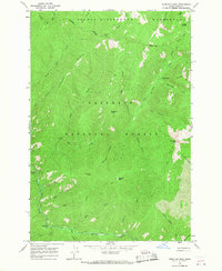
1966 Map of Vermilion Peak
USGS Topo · Published 1968About this map
Meadow Creek Guard Station stands as the primary outpost in this mid-1960s survey of the remote Idaho interior. The landscape is defined by the high elevations of Vermilion Peak and Copper Ridge, where the Nez Perce National Forest meets the Selway-Bitterroot Wilderness. This era of forest management is captured through a network of primitive transportation routes, including the Boundary Pack Trail and several unnamed trails that follow the steep contours between drainages like Indian Creek and Meadow Creek. A notable Tramway located near the guard station suggests specialized logistical operations for moving supplies or materials through the steep terrain. The map meticulously documents the drainage network that feeds into the Selway system, with dozens of named water bodies such as No Business Creek and Little Schwar Creek carving through the peaks of Disgrace Butte and Copper Butte.
Find a feature on this map
42 named features on this map. Tap any name to fly to it.
Don’t see what you’re looking for? This feature index may not catch every label — zoom into the map to look around manually.
Map Details
Editions of this 1966 Vermilion Peak Map
2 editions found
Other maps of this area

1911 · Lolo
USGS Topo · 1:250,000

1913 · Lolo
USGS Topo · 1:250,000

1956 · Elk City
USGS Topo · 1:250,000

1956 · Hamilton
USGS Topo · 1:250,000

1959 · Hamilton
USGS Topo · 1:250,000

1960 · Elk City
USGS Topo · 1:250,000

1960 · Hamilton
USGS Topo · 1:250,000

1964 · Hamilton
USGS Topo · 1:250,000

1966 · Selway Falls
USGS Topo · 1:24,000

1966 · Green Mtn.
USGS Topo · 1:24,000