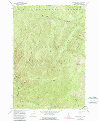
1966 Map of Vermilion Peak
USGS Topo · Published 1987About this map
Nezperce National Forest and the Selway-Bitterroot Wilderness dominate this high-elevation landscape as it appeared in the mid-1960s. The area is defined by a dense network of mountain drainage systems, where Meadow Creek and its many tributaries, including Disgrace Creek and Shake Creek, carve through the steep terrain. Human presence is minimal, centered primarily on the Meadow Creek Work Center in the southwestern corner. The map reveals an extensive system of backcountry infrastructure, with the National Recreation Trail and various routes like the Boundary Pack Trail providing the only access across high points such as Vermilion Peak and Copper Ridge. These trails follow natural lines between landmarks like Little Copper Butte and Drake Saddle, illustrating how the forest was managed and navigated before modern motorized access became a standard in such protected wilderness areas.
Find a feature on this map
42 named features on this map. Tap any name to fly to it.
Don’t see what you’re looking for? This feature index may not catch every label — zoom into the map to look around manually.
Map Details
Editions of this 1966 Vermilion Peak Map
2 editions found
Other maps of this area

1911 · Lolo
USGS Topo · 1:250,000

1913 · Lolo
USGS Topo · 1:250,000

1956 · Elk City
USGS Topo · 1:250,000

1956 · Hamilton
USGS Topo · 1:250,000

1959 · Hamilton
USGS Topo · 1:250,000

1960 · Elk City
USGS Topo · 1:250,000

1960 · Hamilton
USGS Topo · 1:250,000

1964 · Hamilton
USGS Topo · 1:250,000

1966 · Selway Falls
USGS Topo · 1:24,000

1966 · Green Mtn.
USGS Topo · 1:24,000