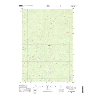
2020 Map of Black Hawk Mountain
USGS Topo · Published 2020About this map
Nez Perce National Forest dominates this landscape in Idaho County, where steep drainages and high ridges define the terrain south of the Bitterroot range. The topography is anchored by the prominent Black Hawk Mtn and the long expanse of Simmons Ridge to the north. Waterways such as Red River and Siegel Cr carve through the mountain passes, illustrating the complex hydrology of the Idaho backcountry. Access to this isolated region is marked by few roads, notably Hot Springs Rd and French Gl Rd, which trace the lower elevations near French Gulch. This survey provides a precise view of the land before significant modern development, documenting the natural landmarks like Blue Ribbon Mtn and Flatiron Ridge that have long served as navigational waypoints for foresters and explorers.
Find a feature on this map
33 named features on this map. Tap any name to fly to it.
Don’t see what you’re looking for? This feature index may not catch every label — zoom into the map to look around manually.
Map Details
Editions of this 2020 Black Hawk Mountain Map
This is the sole edition of this map. No revisions or reprints were ever made.
Other maps of this area

1956 · Elk City
USGS Topo · 1:250,000

1960 · Elk City
USGS Topo · 1:250,000

1966 · Elk City
USGS Topo · 1:24,000

1966 · Black Hawk Mtn
USGS Topo · 1:24,000

1966 · Lick Point
USGS Topo · 1:24,000

1966 · Sable Hill
USGS Topo · 1:24,000

1966 · Anderson Butte
USGS Topo · 1:24,000
1966 · Vermilion Peak
USGS Topo · 1:24,000

1977 · Boston Mtn
USGS Topo · 1:24,000

1978 · Moose Butte
USGS Topo · 1:24,000