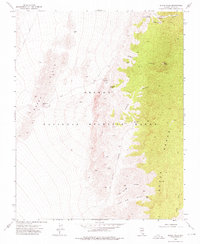
1973 Map of Black Hills
USGS Topo · Published 1976About this map
The Desert National Wildlife Range dominates this mid-1970s survey of Clark County, defined by the stark transition between the Black Hills and the high elevations of the Sheep Range. This arid environment is marked by essential water sources such as Upper Deadman Spring and Rye Patch Spring, which serve as vital landmarks in a landscape sculpted by deep drainage systems. Movement through the area relies on a sparse network of unimproved routes, including Alamo Road and Cow Camp Road, which provide access to strategic points like Black Hills Gap. Canyons such as Joe May Canyon and Picture Canyon reveal the complex topography of the eastern slopes, where features like the Joe May Guzzler indicate modern efforts to manage wildlife resources in this high-desert setting.
Find a feature on this map
21 named features on this map. Tap any name to fly to it.
Don’t see what you’re looking for? This feature index may not catch every label — zoom into the map to look around manually.
Map Details
Editions of this 1973 Black Hills Map
This is the sole edition of this map. No revisions or reprints were ever made.
Other maps of this area

1907 · Las Vegas
USGS Topo · 1:250,000

1908 · Las Vegas
USGS Topo · 1:250,000

1945 · Sheep Range
USGS Topo · 1:125,000

1952 · Corn Creek Springs
USGS Topo · 1:62,500

1952 · Gass Peak
USGS Topo · 1:62,500

1954 · Las Vegas
USGS Topo · 1:250,000

1957 · Las Vegas
USGS Topo · 1:250,000

1959 · Las Vegas
USGS Topo · 1:250,000

1960 · Hayford Peak
USGS Topo · 1:62,500

1962 · Las Vegas
USGS Topo · 1:250,000