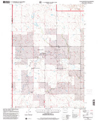
1998 Map of Black Horse Butte
USGS Topo · Published 2001About this map
Standing Rock Indian Reservation Boundary cuts across this expansive landscape in Corson County, where the sprawling Grand River National Grassland dominates the terrain. The map documents a sparsely populated ranching economy defined by family operations including M Gebhart Ranch, B Parrett Ranch, and H Baer Ranch. This 1998 revision of earlier topographical data reveals a network of seasonal watercourses like Black Horse Butte Creek, Darling Creek, and Beef Creek that drain toward the Grand River. Notable elevations like Black Horse Butte and Twin Butte serve as primary landmarks for orientation in this open prairie. For genealogists and local historians, the inclusion of specific ranch names and a lone Cem provides important clues to the homesteading patterns and lineage of the late 20th-century Dakotas.
Find a feature on this map
19 named features on this map. Tap any name to fly to it.
Don’t see what you’re looking for? This feature index may not catch every label — zoom into the map to look around manually.
Map Details
Editions of this 1998 Black Horse Butte Map
This is the sole edition of this map. No revisions or reprints were ever made.
Other maps of this area

1953 · McIntosh
USGS Topo · 1:250,000

1954 · Lemmon
USGS Topo · 1:250,000

1957 · Lemmon
USGS Topo · 1:250,000

1958 · McIntosh
USGS Topo · 1:250,000

1972 · Black Horse Butte NW
USGS Topo · 1:24,000

1972 · Black Horse Butte
USGS Topo · 1:24,000

1972 · Twin Butte
USGS Topo · 1:24,000

1972 · Black Horse Butte NE
USGS Topo · 1:24,000

1980 · McIntosh
USGS Topo · 1:100,000

1982 · Glad Valley
USGS Topo · 1:24,000