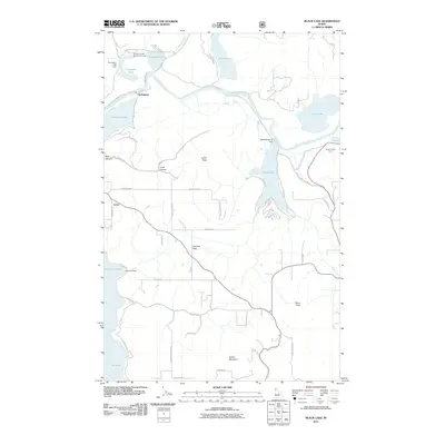
2011 Map of Black Lake
USGS Topo · Published 2011About this map
The Coeur d'Alene River winds through a chain of lateral lakes, defining a landscape where water and low-lying flats dictate the patterns of human settlement. Small communities like Springston, Lacon, and Bell Canyon are situated near these water bodies, which include Black Lake, Thompson Lake, and Anderson Lake. The river's floodplain is punctuated by features with traditional names such as Ni'st'ek'we'st Flat and Sqwe'mu'lmkhw, indicating a long-standing cultural layer beneath the modern agricultural and recreational use of the land. Moving away from the river, the terrain rises sharply toward Lamb Peak and Indian Mountain. On the higher ground of Harrison Flats, a network of rural roads such as E Sunset Dr and S Gem Rd connect various homesteads, while landmarks like the Thompson Lake Dam highlight the management of this complex waterway system.
Find a feature on this map
53 named features on this map. Tap any name to fly to it.
Don’t see what you’re looking for? This feature index may not catch every label — zoom into the map to look around manually.
Map Details
Editions of this 2011 Black Lake Map
This is the sole edition of this map. No revisions or reprints were ever made.
Other maps of this area

1903 · Rathdrum
USGS Topo · 1:125,000

1955 · Spokane
USGS Topo · 1:250,000

1957 · St. Maries
USGS Topo · 1:62,500

1957 · Plummer
USGS Topo · 1:62,500

1957 · Coeur D'Alene
USGS Topo · 1:62,500

1957 · Lane
USGS Topo · 1:62,500

1958 · Spokane
USGS Topo · 1:250,000

1975 · Plummer SE
USGS Topo · 1:24,000

1975 · Coeur D'Alene SE
USGS Topo · 1:24,000

1975 · Plummer NE
USGS Topo · 1:24,000