
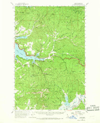
1957 Map of Lane
USGS Topo · Published 1960About this map
Coeur D'Alene Lake and its many timbered inlets form the heart of this Idaho landscape, where the Coeur D'Alene National Forest encompasses the steep drainages of the Bitterroot Range. The 1950s terrain reveals a mix of early 20th-century transportation and resource extraction, notably the Union Pacific rail line running through the community of Lane and the historic Mullan Tree Historic Site near the Fourth of July Canyon. Mining history is preserved at the Caribou Mine and Gray Wolf Mine, while the Elk Patrol Lookout and Airway Beacon 27 atop Mount Coeur d'Alene highlight the era's fire watch and aviation infrastructure. Small shoreline settlements like Eddyville and Silver Beach represent the local development along the lake before the expansion of modern highways through the steep Wolf Lodge Creek drainage.
Find a feature on this map
94 named features on this map. Tap any name to fly to it.
Don’t see what you’re looking for? This feature index may not catch every label — zoom into the map to look around manually.
Map Details
Editions of this 1957 Lane Map
2 editions found
Other maps of this area

1903 · Rathdrum
USGS Topo · 1:125,000

1909 · Cataldo
USGS Topo · 1:125,000

1911 · Cataldo
USGS Topo · 1:125,000

1950 · Rochat Peak
USGS Topo · 1:24,000

1952 · Rochat Peak
USGS Topo · 1:24,000

1955 · Spokane
USGS Topo · 1:250,000

1957 · St. Maries
USGS Topo · 1:62,500

1957 · Kingston
USGS Topo · 1:62,500

1957 · Plummer
USGS Topo · 1:62,500

1957 · Coeur D'Alene
USGS Topo · 1:62,500