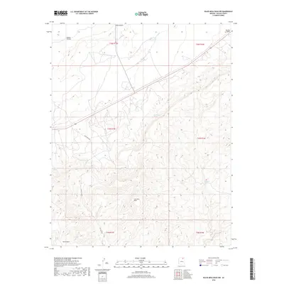
2018 Map of Black Mesa Wash NW
USGS Topo · Published 2018About this map
Shonto Plateau dominates the northwestern corner of this Navajo County landscape, where the high desert floor is deeply incised by drainage networks. The drainage of Shonto Wash and the prominent incision of Shonto Canyon dictate the movement of local travel, while Coal Mine Wash cuts through the southern reaches of the quadrangle. This area of the Navajo Nation is defined by its critical water sources, including Pat Williams Spring, Willow Spring, and Frank Isaac Spring. In the northeast, the terrain opens into the Klethla Valley, which is traversed by Highway 160. Near the southern boundary, the distinct landmark of Yellow Butte rises from the plateau, while Indian Rte 6620 provides a primary route through the undulating system of ridges and washes.
Find a feature on this map
18 named features on this map. Tap any name to fly to it.
Don’t see what you’re looking for? This feature index may not catch every label — zoom into the map to look around manually.
Map Details
Editions of this 2018 Black Mesa Wash NW Map
This is the sole edition of this map. No revisions or reprints were ever made.
Other maps of this area

1883 · Marsh Pass
USGS Topo · 1:250,000

1892 · Marsh Pass
USGS Topo · 1:250,000

1956 · Marble Canyon
USGS Topo · 1:250,000

1959 · Marble Canyon
USGS Topo · 1:250,000

1961 · Marble Canyon
USGS Topo · 1:250,000

1970 · Cow Springs
USGS Topo · 1:24,000
1970 · Kydestea Spring
USGS Topo · 1:24,000

1970 · Black Mesa Wash NW
USGS Topo · 1:24,000

1970 · Whirlwind Rock
USGS Topo · 1:24,000

1970 · Shonto SE
USGS Topo · 1:24,000