
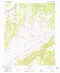
1970 Map of Shonto SE
USGS Topo · Published 1973About this map
The high desert landscape of the Navajo Indian Reservation dominates this survey, which captures the distinct topographic transition from the elevated Shonto Plateau down into the expansive Klethla Valley. The geography is defined by erosion and seasonal water flow, most notably along John Smith Wash and around a localized Spring. Human presence in this environment is characterized by sparse, functional infrastructure, such as a remote Corral and several widely spaced Water Tanks.
Find a feature on this map
12 named features on this map. Tap any name to fly to it.
Don’t see what you’re looking for? This feature index may not catch every label — zoom into the map to look around manually.
Map Details
Editions of this 1970 Shonto SE Map
2 editions found
Other maps of this area

1883 · Marsh Pass
USGS Topo · 1:250,000

1892 · Marsh Pass
USGS Topo · 1:250,000

1956 · Marble Canyon
USGS Topo · 1:250,000

1959 · Marble Canyon
USGS Topo · 1:250,000

1961 · Marble Canyon
USGS Topo · 1:250,000

1968 · Marsh Pass
USGS Topo · 1:24,000

1970 · Black Mesa Wash NW
USGS Topo · 1:24,000
1970 · Betatakin Ruin
USGS Topo · 1:24,000
1970 · Shonto
USGS Topo · 1:24,000
1970 · Black Mesa Wash NE
USGS Topo · 1:24,000