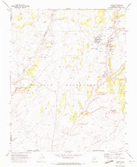
1970 Map of Shonto
USGS Topo · Published 1973About this map
Shonto serves as the focal point of this high-desert landscape on the Navajo Indian Reservation, where the community infrastructure is clearly mapped out. Significant cultural and historical sites are documented throughout the drainage basins, including ancient Cliff Dwellings and Petroglyphs that speak to the long human history of the area. The local economy and social life are reflected in the presence of a Trading Post, Rodeo Grounds, and the Shonto Boarding Sch, while an adjacent Shonto Airstrip provides a modern link to the region. The map reveals a complex system of seasonal water sources such as Shonto Spring and the Starting of the Water Spring, which are critical for the Klethla Valley region. Topographically, the land is defined by the expansive Shonto Plateau and striking geological features like Saneneheck Rock.
Find a feature on this map
28 named features on this map. Tap any name to fly to it.
Don’t see what you’re looking for? This feature index may not catch every label — zoom into the map to look around manually.
Map Details
Editions of this 1970 Shonto Map
This is the sole edition of this map. No revisions or reprints were ever made.
Other maps of this area

1883 · Marsh Pass
USGS Topo · 1:250,000

1892 · Marsh Pass
USGS Topo · 1:250,000

1956 · Marble Canyon
USGS Topo · 1:250,000

1959 · Marble Canyon
USGS Topo · 1:250,000

1961 · Marble Canyon
USGS Topo · 1:250,000

1970 · Cow Springs
USGS Topo · 1:24,000

1970 · Black Mesa Wash NW
USGS Topo · 1:24,000

1970 · Whirlwind Rock
USGS Topo · 1:24,000

1970 · Shonto SE
USGS Topo · 1:24,000
1970 · Betatakin Ruin
USGS Topo · 1:24,000