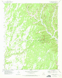
1970 Map of Betatakin Ruin
USGS Topo · Published 1973About this map
Navajo National Monument centers this 1970s survey, highlighting the preserved ancestral sites within the Navajo Indian Reservation. The terrain is dominated by the deep incisions of Betatakin Canyon and Keet Seel Canyon as they cut through the high elevations of Skeleton Mesa. Archaeologically significant Cliff Dwelling sites are noted along these canyon walls, accessible primarily via a network of Pack Trail and Sandal Trail routes.
Find a feature on this map
33 named features on this map. Tap any name to fly to it.
Don’t see what you’re looking for? This feature index may not catch every label — zoom into the map to look around manually.
Map Details
Editions of this 1970 Betatakin Ruin Map
2 editions found
Other maps of this area

1883 · Marsh Pass
USGS Topo · 1:250,000

1892 · Marsh Pass
USGS Topo · 1:250,000

1952 · Agathla Peak 2 SW
USGS Topo · 1:24,000

1952 · Boot Mesa
USGS Topo · 1:62,500

1956 · Marble Canyon
USGS Topo · 1:250,000

1959 · Marble Canyon
USGS Topo · 1:250,000

1961 · Marble Canyon
USGS Topo · 1:250,000

1968 · Marsh Pass
USGS Topo · 1:24,000

1970 · Shonto SE
USGS Topo · 1:24,000
1970 · Tall Mountain
USGS Topo · 1:24,000