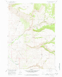
1960 Map of Black Mountain
USGS Topo · Published 1978About this map
Big Horn National Forest dominates this mountain landscape, defined by the dramatic descent of Shell Creek through the steep-walled Shell Canyon. The 1960 field survey captures an era of scientific and recreational activity in the wilderness, evidenced by the Iowa State Univ Geology Camp and the nearby Post Creek Picnic Area. Water management for lower-lying basins is clearly visible through a network of high-altitude irrigation features, including the Kershner Ditch, High Line Ditch, and Hatten Ditch, which trace the contours above Trapper Creek. To the south, the Trapper Lodge Ranch sits near the confluence of mountain streams, while distinctive landmarks like Elephant Head Rock and Chimney Rock serve as natural navigational aids. The presence of a Gaging Sta on Shell Creek underscores the importance of monitoring snowmelt and runoff in this critical watershed.
Find a feature on this map
76 named features on this map. Tap any name to fly to it.
Don’t see what you’re looking for? This feature index may not catch every label — zoom into the map to look around manually.
Map Details
Editions of this 1960 Black Mountain Map
3 editions found
Other maps of this area

1898 · Bald Mountain
USGS Topo · 1:125,000

1901 · Bald Mountain
USGS Topo · 1:125,000

1955 · Sheridan
USGS Topo · 1:250,000

1958 · Sheridan
USGS Topo · 1:250,000

1960 · Shell Falls
USGS Topo · 1:24,000

1960 · White Sulphur Spring
USGS Topo · 1:24,000

1960 · Black Mountain
USGS Topo · 1:24,000

1960 · Granite Pass
USGS Topo · 1:24,000

1960 · Manderson NE
USGS Topo · 1:24,000

1960 · Hidden Tepee Creek
USGS Topo · 1:24,000