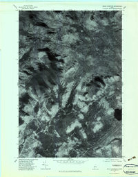
1977 Map of Black Mountain
USGS Topo · Published 1983About this map
Tim Pond sits at the base of the highlands in this remote corner of Franklin County, where the 1977 aerial imagery reveals a landscape shaped by high-elevation drainage and timberland. This orthophotograph, produced by the Geological Survey, captures the textured forest canopy across Black Mountain and Bob Mountain during a late October flight. The drainage patterns are particularly clear, showing the headwaters of the North Branch Alder Stream and South Branch Alder Stream as they carve through the terrain. Unlike traditional topographic maps, this imagery provides a direct view of the land cover and logging access routes as they existed in the late 1970s, anchoring the relationship between landmarks like Maple Hill and the adjacent water bodies of Big Sag Brook and Black Brook.
Find a feature on this map
8 named features on this map. Tap any name to fly to it.
Don’t see what you’re looking for? This feature index may not catch every label — zoom into the map to look around manually.
Map Details
Editions of this 1977 Black Mountain Map
This is the sole edition of this map. No revisions or reprints were ever made.
Other maps of this area

1928 · Chain Lakes
USGS Topo · 1:48,000

1931 · Cupsuptic
USGS Topo · 1:48,000

1932 · Kennebago Lake
USGS Topo · 1:48,000

1932 · Arnold Pond
USGS Topo · 1:48,000

1932 · Chain Lakes
USGS Topo · 1:62,500

1934 · Cupsuptic
USGS Topo · 1:62,500

1935 · Kennebago Lake
USGS Topo · 1:62,500

1935 · Chain Lakes
USGS Topo · 1:62,500

1935 · Cupsuptic
USGS Topo · 1:62,500

1935 · Arnold Pond
USGS Topo · 1:62,500
Featured Places
- Tim Pond Township, ME
- Stetsontown Township, ME
- Alder Stream Township, ME
- Seven Ponds Township, ME
- Franklin County, ME