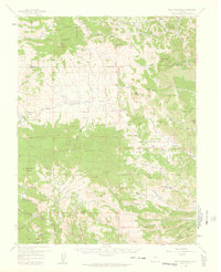
1959 Map of Black Mountain
USGS Topo · Published 1961About this map
Waugh Mountain and the southern reaches of the Pike National Forest dominate this high-altitude landscape of central Colorado. The map reveals a remote ranching economy defined by family holdings such as the V V N Ranch, Stirrup Ranch, and Hammond Ranch. The drainages of Tallahassee Creek and its north, middle, and south branches provide the primary orientation for these homesteads, many of which are connected only by trails or jeep trails.
Find a feature on this map
74 named features on this map. Tap any name to fly to it.
Don’t see what you’re looking for? This feature index may not catch every label — zoom into the map to look around manually.
Map Details
Editions of this 1959 Black Mountain Map
3 editions found

Other maps of this area

1889 · Canon City
USGS Topo · 1:125,000

1892 · Canon City
USGS Topo · 1:125,000

1894 · Pikes Peak
USGS Topo · 1:125,000

1901 · Pikes Peak
USGS Topo · 1:125,000

1942 · Cover Mtn.
USGS Topo · 1:62,500

1948 · Cover Mtn.
USGS Topo · 1:62,500

1954 · Pueblo
USGS Topo · 1:250,000

1956 · Cameron Mountain
USGS Topo · 1:62,500

1957 · Pueblo
USGS Topo · 1:250,000

1958 · Pueblo
USGS Topo · 1:250,000