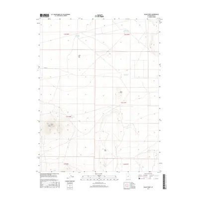
2017 Map of Black Point
USGS Topo · Published 2017About this map
Twin Peaks Spring and a series of isolated water catchments define this arid landscape in Millard County, where human presence is marked primarily by ranching infrastructure. The terrain is characterized by dramatic elevation changes, ranging from the level expanse of Clear Spot Flat to the prominent volcanic formations of Lava Ridge and Black Point. In a region where water is the most critical resource, several engineered features such as Hole-in-the-Rock Reservoir, Black Point Reservoir, and the Clear Spot Reservoirs illustrate the effort to manage seasonal runoff for livestock and land use. The presence of Twin Peaks and N Twin Peak provides significant navigational landmarks in a territory divided by the public land survey system, showing the township and range grids of T22S through T24S.
Find a feature on this map
16 named features on this map. Tap any name to fly to it.
Don’t see what you’re looking for? This feature index may not catch every label — zoom into the map to look around manually.
Map Details
Editions of this 2017 Black Point Map
This is the sole edition of this map. No revisions or reprints were ever made.
Other maps of this area

1885 · Beaver
USGS Topo · 1:250,000

1953 · Richfield
USGS Topo · 1:250,000

1958 · Richfield
USGS Topo · 1:250,000

1962 · Tabernacle Hill
USGS Topo · 1:62,500

1962 · Cove Fort
USGS Topo · 1:62,500

1973 · Cruz
USGS Topo · 1:24,000

1973 · Antelope Spring
USGS Topo · 1:24,000
1973 · Borden
USGS Topo · 1:24,000

1980 · Richfield
USGS Topo · 1:100,000
1986 · Sixmile Point
USGS Topo · 1:24,000