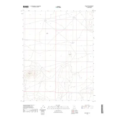
2023 Map of Black Point
USGS Topo · Published 2023About this map
Lava Ridge and the volcanic formations of Millard County dominate this high-desert landscape, defined by dramatic elevation changes and essential water catchments. The terrain is anchored by the prominent North Twin Peak, part of the larger Twin Peaks range, which rises sharply above the surrounding flats. This 2023 survey illustrates the critical role of water management in an arid environment, where man-made catchments like Hole-in-the-Rock Reservoir, Black Point Reservoir, and the Clear Spot Reservoirs are strategically placed to collect runoff. The presence of Twin Peaks Spring and the expansive Clear Spot Flat suggests a landscape shaped by both intermittent moisture and ancient geological activity. Transportation in the area is minimal, primarily limited to local routes such as W 6500 South St, which skirts the northern edge of the volcanic features.
Find a feature on this map
11 named features on this map. Tap any name to fly to it.
Don’t see what you’re looking for? This feature index may not catch every label — zoom into the map to look around manually.
Map Details
Editions of this 2023 Black Point Map
This is the sole edition of this map. No revisions or reprints were ever made.
Other maps of this area

1885 · Beaver
USGS Topo · 1:250,000

1953 · Richfield
USGS Topo · 1:250,000

1958 · Richfield
USGS Topo · 1:250,000

1962 · Tabernacle Hill
USGS Topo · 1:62,500

1962 · Cove Fort
USGS Topo · 1:62,500

1973 · Cruz
USGS Topo · 1:24,000

1973 · Antelope Spring
USGS Topo · 1:24,000
1973 · Borden
USGS Topo · 1:24,000

1980 · Richfield
USGS Topo · 1:100,000
1986 · Sixmile Point
USGS Topo · 1:24,000