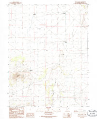
1986 Map of Black Point
USGS Topo · Published 1986About this map
Lava Ridge dominates the southeastern portion of this Millard County landscape, a stark volcanic feature that defines the local topography. This 1986 provisional survey captures a remote expanse where water management is the primary sign of human modification. Scattered throughout the arid basin are critical water catchments such as Black Point Reservoir, the Hole-in-the-Rock Reservoir, and the Clear Spot Reservoirs, which likely served livestock or transit needs across the Clear Spot Flat.
Find a feature on this map
9 named features on this map. Tap any name to fly to it.
Don’t see what you’re looking for? This feature index may not catch every label — zoom into the map to look around manually.
Map Details
Editions of this 1986 Black Point Map
This is the sole edition of this map. No revisions or reprints were ever made.
Other maps of this area

1885 · Beaver
USGS Topo · 1:250,000

1953 · Richfield
USGS Topo · 1:250,000

1958 · Richfield
USGS Topo · 1:250,000

1962 · Tabernacle Hill
USGS Topo · 1:62,500

1962 · Cove Fort
USGS Topo · 1:62,500

1973 · Cruz
USGS Topo · 1:24,000

1973 · Antelope Spring
USGS Topo · 1:24,000
1973 · Borden
USGS Topo · 1:24,000

1980 · Richfield
USGS Topo · 1:100,000
1986 · Sixmile Point
USGS Topo · 1:24,000