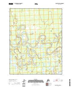
2018 Map of Black River C-6 NW
USGS Topo · Published 2018About this map
Draanjik River meanders across this landscape, defining a complex network of oxbows and wetlands in the interior of Alaska. The settlement of Chalkyitsik is positioned along the riverbank in the southeastern quadrant, serving as a rare point of human habitation in a region dominated by water and shifting river channels. The surrounding terrain is characterized by a high density of lakes, including the expansive Big Timber Lake to the south and Marten Lake near the eastern boundary. These water bodies, along with Jokoei Lake, represent the hydrological richness of the Yukon-Koyukuk region, where the river's historical migration has left a footprint of former channels and basins. This USGS survey provides a detailed view of the natural water systems and the isolated community of Chalkyitsik as they existed in the early 21st century.
Find a feature on this map
9 named features on this map. Tap any name to fly to it.
Don’t see what you’re looking for? This feature index may not catch every label — zoom into the map to look around manually.
Map Details
Editions of this 2018 Black River C-6 NW Map
This is the sole edition of this map. No revisions or reprints were ever made.
Other maps of this area

1951 · Fort Yukon
USGS Topo · 1:250,000

1951 · Black River
USGS Topo · 1:250,000

1956 · Fort Yukon C-1
USGS Topo · 1:63,360

1956 · Black River D-6
USGS Topo · 1:63,360

1956 · Black River C-6
USGS Topo · 1:63,360
1956 · Fort Yukon D-1
USGS Topo · 1:63,360

1956 · Fort Yukon
USGS Topo · 1:250,000

1956 · Black River
USGS Topo · 1:250,000

1964 · Black River
USGS Topo · 1:250,000
2018 · Black River C-6 SE
USGS Topo · 1:25,000