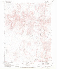
1968 Map of Black Rock Summit
USGS Topo · Published 1972About this map
The Pancake Range dominates this late-1960s landscape, providing a high-elevation divide between the broad Big Sand Springs Valley and the more confined Big Round Valley. This survey, conducted in cooperation with the Atomic Energy Commission, captures the region's volcanic character, notably at Black Rock Summit and the dramatic escarpment known as The Wall. The presence of a Lava field and a Cinder Pit reflects the local geologic history, while scattered Prospects suggest the era's ongoing mineral exploration. Human infrastructure remains sparse in this arid terrain, focused primarily on essential resource points like Black Rock Spring and a remote Radio Tower, all interconnected by a network of Jeep Trails.
Find a feature on this map
13 named features on this map. Tap any name to fly to it.
Don’t see what you’re looking for? This feature index may not catch every label — zoom into the map to look around manually.
Map Details
Editions of this 1968 Black Rock Summit Map
This is the sole edition of this map. No revisions or reprints were ever made.
Other maps of this area

1956 · Lund
USGS Topo · 1:250,000

1956 · Tonopah
USGS Topo · 1:250,000

1959 · Tonopah
USGS Topo · 1:250,000

1960 · Lund
USGS Topo · 1:250,000

1962 · Tonopah
USGS Topo · 1:250,000

1967 · Lunar Crater
USGS Topo · 1:62,500

1967 · Moores Station
USGS Topo · 1:62,500

1967 · Moores Station SE
USGS Topo · 1:24,000

1967 · Lunar Crater
USGS Topo · 1:24,000

1967 · Chaos Creek
USGS Topo · 1:24,000