
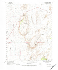
1967 Map of Lunar Crater
USGS Topo · Published 1970About this map
Pancake Range dominates this landscape, revealing a stark volcanic topography mapped in cooperation with the Atomic Energy Commission in the late 1960s. The region is defined by prominent geological formations like the Lunar Crater and the aptly named Easy Chair Crater, surrounded by the Little Lunar Cuesta and Lunar Cuesta. Human presence is sparse, centered on vital water sources like Rays Well and the highway support at Blue Jay Hy Maintenance Sta. This survey captures the area's transition from open range to a site of intense scientific and geological study, with distinct terrain features such as North Kidney Butte and the sheer face of The Wall providing clear landmarks for navigation. Seasonal water sources, including Iceberg Spring and Rattlesnake Springs, appear alongside the expansive Hot Creek Valley, marking the essential points of survival in this high-desert environment.
Find a feature on this map
33 named features on this map. Tap any name to fly to it.
Don’t see what you’re looking for? This feature index may not catch every label — zoom into the map to look around manually.
Map Details
Editions of this 1967 Lunar Crater Map
2 editions found
Other maps of this area

1956 · Lund
USGS Topo · 1:250,000

1956 · Tonopah
USGS Topo · 1:250,000

1959 · Tonopah
USGS Topo · 1:250,000

1960 · Lund
USGS Topo · 1:250,000

1962 · Tonopah
USGS Topo · 1:250,000

1967 · Moores Station
USGS Topo · 1:62,500

1967 · Blue Jay Spring
USGS Topo · 1:24,000

1967 · Moores Station SE
USGS Topo · 1:24,000

1967 · Buckwheat Rim
USGS Topo · 1:24,000

1967 · Palisade Mesa
USGS Topo · 1:24,000