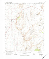
1967 Map of Lunar Crater
USGS Topo · Published 1984About this map
Lunar Cuesta and the volcanic landscape of the Pancake Range dominate this 1967 survey of central Nevada. The map is notable for its depiction of distinct geological formations, including the prominent Lunar Crater and the curiously named Easy Chair Crater. This area, mapped in cooperation with the Atomic Energy Commission, illustrates a sparse high-desert environment where water sources like Sandy Summit Spring and Iceberg Spring were critical for travelers and surveyors alike. To the west, the broad Hot Creek Valley contains the Blue Jay Hy Maintenance Sta, one of the few human outposts in this territory. The cartography reveals a network of primitive transportation routes, marked as Jeep Trails, winding through features like Monocline Canyon and Buckwheat Rim, connecting isolated points such as Rays Well and various unnamed mines.
Find a feature on this map
34 named features on this map. Tap any name to fly to it.
Don’t see what you’re looking for? This feature index may not catch every label — zoom into the map to look around manually.
Map Details
Editions of this 1967 Lunar Crater Map
2 editions found
Other maps of this area

1956 · Lund
USGS Topo · 1:250,000

1956 · Tonopah
USGS Topo · 1:250,000

1959 · Tonopah
USGS Topo · 1:250,000

1960 · Lund
USGS Topo · 1:250,000

1962 · Tonopah
USGS Topo · 1:250,000

1967 · Lunar Crater
USGS Topo · 1:62,500

1967 · Moores Station
USGS Topo · 1:62,500

1967 · Blue Jay Spring
USGS Topo · 1:24,000

1967 · Moores Station SE
USGS Topo · 1:24,000

1967 · Buckwheat Rim
USGS Topo · 1:24,000