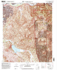
1997 Map of Black Star Canyon
USGS Topo · Published 2000About this map
The Santa Ana River corridor and the high ridges of the Cleveland National Forest define this landscape during the late 1990s. The map captures the transition from the developed riparian zone near Featherly Regional Park to the deep, canyon-cut interior of the Santa Ana Mountains. Significant water management infrastructure is evident at the Santiago Reservoir, also known as Irvine Lake, which is held by the Santiago Dam.
Find a feature on this map
40 named features on this map. Tap any name to fly to it.
Don’t see what you’re looking for? This feature index may not catch every label — zoom into the map to look around manually.
Map Details
Editions of this 1997 Black Star Canyon Map
This is the sole edition of this map. No revisions or reprints were ever made.
Other maps of this area

1896 · Santa Ana
USGS Topo · 1:62,500

1896 · Anaheim
USGS Topo · 1:62,500

1898 · Anaheim
USGS Topo · 1:62,500

1901 · Southern California Sheet No. 1
USGS Topo · 1:250,000

1901 · Santa Ana
USGS Topo · 1:62,500

1901 · Anaheim
USGS Topo · 1:62,500

1902 · Corona
USGS Topo · 1:125,000

1904 · Southern California Sheet No. 1
USGS Topo · 1:250,000

1932 · Orange
USGS Topo · 1:31,680

1932 · Tustin
USGS Topo · 1:31,680