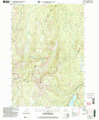
2004 Map of Black Tip
USGS Topo · Published 2007About this map
Upper Payette Lake and the surrounding high country of the Payette National Forest anchor this 2004 revision of the landscape. The terrain is defined by prominent elevations such as Black Tip, Bruin Mtn, and the distinctive spine of Center Ridge. Transportation through these mountain passes is marked by the New Meadows McCall Road and the more primitive Wagon Road trailing near the North Fork Payette River.
Find a feature on this map
32 named features on this map. Tap any name to fly to it.
Don’t see what you’re looking for? This feature index may not catch every label — zoom into the map to look around manually.
Map Details
Editions of this 2004 Black Tip Map
This is the sole edition of this map. No revisions or reprints were ever made.
Other maps of this area

1938 · Riggins
USGS Topo · 1:96,000

1945 · Riggins
USGS Topo · 1:125,000

1955 · Grangeville
USGS Topo · 1:250,000

1956 · Burgdorf
USGS Topo · 1:62,500

1956 · Elk City
USGS Topo · 1:250,000

1959 · Grangeville
USGS Topo · 1:250,000

1960 · Elk City
USGS Topo · 1:250,000

1963 · Granite Lake
USGS Topo · 1:24,000

1963 · Black Tip
USGS Topo · 1:24,000

1963 · Hershey Point
USGS Topo · 1:24,000