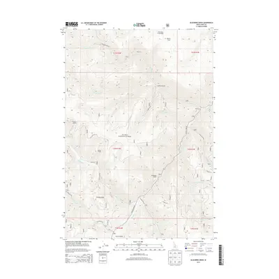
2013 Map of Blackbird Creek
USGS Topo · Published 2013About this map
The Cobalt Mine and surrounding drainage basins define this portion of the Salmon National Forest in central Idaho. The landscape is characterized by a dense network of gulches and creeks, including Quartz Gulch, Ludwig Gulch, and Slippery Cr, all flowing toward the prominent north-south corridor of Panther Cr. Human presence is marked by isolated outposts such as Miller Ranch and Degan Ranch, which appear alongside a complex system of forest roads like Blackbird Creek Rd and Yellowjacket Rd. This map captures the intersection of industrial mining history and rugged backcountry ranching, with prominent landmarks such as Porphyry Ridge and Little Deer Creek Ridge rising between the deep-cut valleys of Musgrove Cr and Blackbird Cr.
Find a feature on this map
36 named features on this map. Tap any name to fly to it.
Don’t see what you’re looking for? This feature index may not catch every label — zoom into the map to look around manually.
Map Details
Editions of this 2013 Blackbird Creek Map
This is the sole edition of this map. No revisions or reprints were ever made.
Other maps of this area

1950 · Blackbird Mtn
USGS Topo · 1:62,500

1950 · Leesburg
USGS Topo · 1:62,500

1951 · Leesburg
USGS Topo · 1:62,500

1951 · Blackbird Mtn
USGS Topo · 1:62,500

1956 · Elk City
USGS Topo · 1:250,000

1957 · Challis
USGS Topo · 1:250,000

1960 · Elk City
USGS Topo · 1:250,000

1960 · Challis
USGS Topo · 1:250,000

1963 · Challis
USGS Topo · 1:250,000
1963 · Opal Lake
USGS Topo · 1:24,000