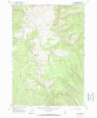
1963 Map of Opal Lake
USGS Topo · Published 1964About this map
Panther Creek carves a deep path through this portion of the Salmon National Forest, anchoring a landscape of high basins and remote mining activity as documented in 1963. The map reveals the isolation of early Lemhi County life, highlighting localized cattle or sheep operations at the Merritt Ranch and Kingsbury Ranch in the northern reaches of McGowan Basin. Evidence of the region’s mineral interest is clear at the Rabbit Foot Mine and the Singheiser area, where a network of trails and jeep tracks connects these prospects to the primary drainage of the creek. To the east, the terrain rises into Moyer Basin and Prairie Basin, while the quiet waters of Opal Lake sit at the head of Opal Creek. This survey provides a precise view of the mid-century wilderness before modern access improved, noting small campgrounds and scattered prospects that defined the Idaho backcountry.
Find a feature on this map
27 named features on this map. Tap any name to fly to it.
Don’t see what you’re looking for? This feature index may not catch every label — zoom into the map to look around manually.
Map Details
Editions of this 1963 Opal Lake Map
2 editions found
Other maps of this area

1950 · Blackbird Mtn
USGS Topo · 1:62,500

1950 · Leesburg
USGS Topo · 1:62,500

1951 · Leesburg
USGS Topo · 1:62,500

1951 · Blackbird Mtn
USGS Topo · 1:62,500

1956 · Elk City
USGS Topo · 1:250,000

1957 · Challis
USGS Topo · 1:250,000

1960 · Elk City
USGS Topo · 1:250,000

1960 · Challis
USGS Topo · 1:250,000

1963 · Challis
USGS Topo · 1:250,000
1963 · Duck Creek Point
USGS Topo · 1:24,000