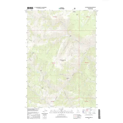
2017 Map of Blackbird Creek
USGS Topo · Published 2017About this map
Salmon National Forest defines this high-elevation landscape in Lemhi County, where a complex network of drainages flows toward the major arterial of Panther Cr. The topography is marked by significant elevation changes, from the heights of Porphyry Ridge and Little Deer Creek Ridge down to deep ravines like McDonald Gulch and French Gulch. This 2017 survey reveals the intricate hydrography of the region, including the headwaters of Blackbird Cr, Musgrove Creek, and Woodtick Cr.
Find a feature on this map
35 named features on this map. Tap any name to fly to it.
Don’t see what you’re looking for? This feature index may not catch every label — zoom into the map to look around manually.
Map Details
Editions of this 2017 Blackbird Creek Map
This is the sole edition of this map. No revisions or reprints were ever made.
Other maps of this area

1950 · Blackbird Mtn
USGS Topo · 1:62,500

1950 · Leesburg
USGS Topo · 1:62,500

1951 · Leesburg
USGS Topo · 1:62,500

1951 · Blackbird Mtn
USGS Topo · 1:62,500

1956 · Elk City
USGS Topo · 1:250,000

1957 · Challis
USGS Topo · 1:250,000

1960 · Elk City
USGS Topo · 1:250,000

1960 · Challis
USGS Topo · 1:250,000

1963 · Challis
USGS Topo · 1:250,000
1963 · Opal Lake
USGS Topo · 1:24,000