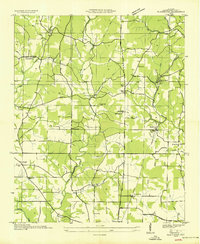
1936 Map of Blackburn
USGS Topo · Published 1936About this map
Little Cypress Creek and Middle Cypress Creek carve through the agricultural landscape of Lauderdale County in this 1936 field examination. The area is defined by a dense network of rural infrastructure, including numerous small schoolhouses like Wilson Sch and Stripling Sch and local religious centers such as Parsonage Chapel and Mt Tabor Ch. The Tennessee Valley Authority's involvement is evident in the transition line running near St Florian, reflecting the era's electrification efforts. Transportation is anchored by the Nashville and Louisville road and the Chisholm Road, while Big Cut Station near Hines points to the area's rail connections. Small settlements like Blackburn and Jacksonburg serve as hubs for the surrounding farmsteads, with family history preserved at the Cedar Grove Cem and Parsonage Cem.
Find a feature on this map
43 named features on this map. Tap any name to fly to it.
Don’t see what you’re looking for? This feature index may not catch every label — zoom into the map to look around manually.
Map Details
Editions of this 1936 Blackburn Map
This is the sole edition of this map. No revisions or reprints were ever made.
Other maps of this area

1905 · Waynesboro
USGS Topo · 1:125,000

1914 · Muscle Shoals
USGS Topo · 1:48,000

1916 · Muscle Shoals
USGS Topo · 1:62,500

1924 · Gravelly Springs
USGS Topo · 1:48,000

1926 · Gravelly Springs
USGS Topo · 1:62,500

1936 · Light
USGS Topo · 1:24,000

1936 · Threet
USGS Topo · 1:24,000

1936 · Cypress Inn
USGS Topo · 1:24,000

1936 · Pruitton
USGS Topo · 1:24,000

1936 · Florence
USGS Topo · 1:24,000