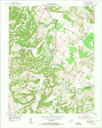
1954 Map of Blackford
USGS Topo · Published 1974About this map
The Illinois Central Railroad serves as a central artery through this rural landscape, connecting the small communities of Sullivan and Blackford during the mid-1950s. The terrain is defined by the winding course of the Tradewater River, which forms the boundary between Crittenden, Union, and Webster counties. The map captures a transition in land use, showing active Strip Mines and several Oil Wells emerging alongside established agricultural life. Family history and community landmarks are prominent, including Nunn Cem, Kilpatrick Cem, and the Historical Grave near Monument Ridge. Small country churches like Enon Ch and Rosebud Ch are scattered among the ridges and hollows, such as Pat Duffy Hollow and Cave Spring Hollow, illustrating the dispersed settlement patterns characteristic of the Kentucky coal field region at this time.
Find a feature on this map
72 named features on this map. Tap any name to fly to it.
Don’t see what you’re looking for? This feature index may not catch every label — zoom into the map to look around manually.
Map Details
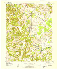
Editions of this 1954 Blackford Map
2 editions found
Other maps of this area

1907 · Morganfield
USGS Topo · 1:62,500

1909 · Providence
USGS Topo · 1:62,500

1916 · Shawneetown
USGS Topo · 1:62,500

1916 · Fords Ferry
USGS Topo · 1:62,500

1921 · Fords Ferry
USGS Topo · 1:48,000

1925 · Cave In Rock
USGS Topo · 1:62,500

1949 · Paducah
USGS Topo · 1:250,000

1950 · Paducah
USGS Topo · 1:250,000
1951 · Bordley
USGS Topo · 1:24,000

1951 · Sturgis
USGS Topo · 1:24,000