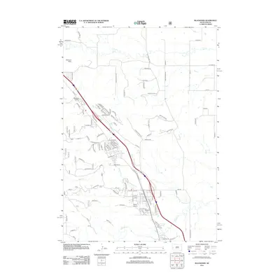
2012 Map of Blackhawk
USGS Topo · Published 2012About this map
Piedmont Butte anchors the northwest corner of this 2012 survey, overlooking a landscape defined by the intersection of steep canyons and residential expansion along the eastern edge of the Black Hills. The suburban development is densely clustered between Stagebarn Canyon and Wards Canyon, where many streets like Brighton St, Manchester St, and Townsend St indicate the growth of local neighborhoods. This map documents a modern transportation corridor following N Hwy 79, which serves as the primary spine for the area's development.
Find a feature on this map
103 named features on this map. Tap any name to fly to it.
Don’t see what you’re looking for? This feature index may not catch every label — zoom into the map to look around manually.
Map Details
Editions of this 2012 Blackhawk Map
This is the sole edition of this map. No revisions or reprints were ever made.
Other maps of this area

1893 · Rapid
USGS Topo · 1:125,000

1898 · Rapid
USGS Topo · 1:125,000

1903 · Rapid
USGS Topo · 1:125,000

1953 · Rapid City 1 SW
USGS Topo · 1:24,000

1953 · Blackhawk
USGS Topo · 1:24,000

1953 · Rapid City East
USGS Topo · 1:24,000

1953 · Piedmont
USGS Topo · 1:24,000

1953 · Rapid City NW
USGS Topo · 1:24,000

1953 · Rapid City West
USGS Topo · 1:24,000
1953 · Tilford
USGS Topo · 1:24,000