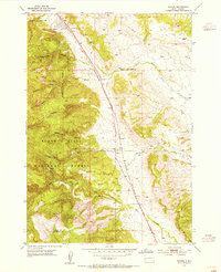
1953 Map of Tilford
USGS Topo · Published 1955About this map
Black Hills National Cemetery lies at the northern edge of this mid-century survey, positioned just south of the Fort Meade Military Boundary. The landscape is defined by the transition from the steep, drainage-carved slopes of the Black Hills National Forest into the lower drainages of Pleasant Valley. The small settlement of Tilford serves as a central waypoint along the Chicago and North Western railroad line, which cuts a straight path through the territory.
Find a feature on this map
22 named features on this map. Tap any name to fly to it.
Don’t see what you’re looking for? This feature index may not catch every label — zoom into the map to look around manually.
Map Details
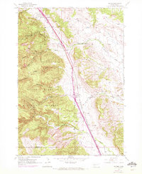
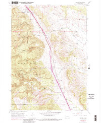
Editions of this 1953 Tilford Map
4 editions found
Historical Maps of Tilford Through Time
129 maps found

1893 Rapid
Meade County, SD

1898 Rapid
Meade County, SD

1903 Rapid
Meade County, SD

1951 Vale SE
Meade County, SD

1951 Volunteer
Meade County, SD

1951 Volunteer SE
Meade County, SD

1953 Bend
Meade County, SD

1953 Cottonwood Draw
Meade County, SD

1953 Elm Creek
Meade County, SD

1953 Fort Meade
Meade County, SD

1953 Fort Meade NE
Meade County, SD

1953 Fort Meade SE
Meade County, SD

1953 Hereford
Meade County, SD

1953 Hereford NE
Meade County, SD

1953 Hereford SE
Meade County, SD

1953 Hereford SW
Meade County, SD

1953 Lone Tree Creek
Meade County, SD

1953 New Underwood NW
Meade County, SD

1953 Rapid City NW
Meade County, SD

1953 South of Volunteer
Meade County, SD

1953 Tilford
Meade County, SD

1953 Viewfield
Meade County, SD

1954 Boneita Springs
Meade County, SD

1954 Dalzell
Meade County, SD

1954 Dalzell NE
Meade County, SD

1954 Dalzell NW
Meade County, SD

1954 Deadman Mountain
Meade County, SD

1954 Elm Springs
Meade County, SD

1954 Elm Springs SW
Meade County, SD

1954 Haydraw
Meade County, SD

1954 Saint Onge SE
Meade County, SD

1954 Wasta NW
Meade County, SD

1955 Howes
Meade County, SD

1957 Owanka NE
Meade County, SD

1957 Owanka NW
Meade County, SD

1959 Enning
Meade County, SD

1959 Fairpoint
Meade County, SD

1959 Fairpoint NW
Meade County, SD

1959 Fairpoint SE
Meade County, SD

1959 Fairpoint SW
Meade County, SD

1959 Redowl
Meade County, SD

1959 Stoneville
Meade County, SD

1959 Union Center
Meade County, SD

1973 Frozen Man Creek
Meade County, SD

1977 Table Top Butte
Meade County, SD

1978 Bull Run Creek
Meade County, SD

1978 Camp Creek
Meade County, SD

1983 Avance
Meade County, SD

1983 Avance SE
Meade County, SD

1983 Big Draw
Meade County, SD

1983 Durkee Lake
Meade County, SD

1983 Lemmon Butte
Meade County, SD

1983 Lemmon Creek
Meade County, SD

1983 Marcus
Meade County, SD

1983 Opal East
Meade County, SD

1983 Opal East SE
Meade County, SD

1983 Opal East SW
Meade County, SD

1983 Opal West SE
Meade County, SD

1983 Plainview
Meade County, SD

1983 Reed Dam
Meade County, SD

1983 Squaw Buttes
Meade County, SD

1983 Thompson Lake
Meade County, SD

1983 Whiteman Owl
Meade County, SD

1983 Whiteman Owl NW
Meade County, SD

1983 Whiteman Owl SE
Meade County, SD

1984 Camp Creek
Meade County, SD

2021 Avance
Meade County, SD

2021 Avance SE
Meade County, SD

2021 Bend
Meade County, SD

2021 Big Draw
Meade County, SD

2021 Boneita Springs
Meade County, SD

2021 Bull Run Creek
Meade County, SD

2021 Camp Creek
Meade County, SD

2021 Cottonwood Draw
Meade County, SD

2021 Dalzell
Meade County, SD

2021 Dalzell NE
Meade County, SD

2021 Dalzell NW
Meade County, SD

2021 Deadman Mountain
Meade County, SD

2021 Durkee Lake
Meade County, SD

2021 Elm Creek
Meade County, SD

2021 Elm Springs
Meade County, SD

2021 Elm Springs SW
Meade County, SD

2021 Enning
Meade County, SD

2021 Fairpoint
Meade County, SD

2021 Fairpoint NW
Meade County, SD

2021 Fairpoint SE
Meade County, SD

2021 Fairpoint SW
Meade County, SD

2021 Fort Meade
Meade County, SD

2021 Fort Meade NE
Meade County, SD

2021 Fort Meade SE
Meade County, SD

2021 Frozen Man Creek
Meade County, SD

2021 Haydraw
Meade County, SD

2021 Hereford
Meade County, SD

2021 Hereford NE
Meade County, SD

2021 Hereford SE
Meade County, SD

2021 Hereford SW
Meade County, SD

2021 Howes
Meade County, SD

2021 Lemmon Butte
Meade County, SD

2021 Lemmon Creek
Meade County, SD

2021 Lone Tree Creek
Meade County, SD

2021 Marcus
Meade County, SD

2021 New Underwood NW
Meade County, SD

2021 Opal East
Meade County, SD

2021 Opal East SE
Meade County, SD

2021 Opal East SW
Meade County, SD

2021 Opal West
Meade County, SD

2021 Opal West SE
Meade County, SD

2021 Owanka NE
Meade County, SD

2021 Owanka NW
Meade County, SD

2021 Plainview
Meade County, SD

2021 Rapid City NW
Meade County, SD

2021 Redowl
Meade County, SD

2021 Reed Dam
Meade County, SD

2021 Saint Onge SE
Meade County, SD

2021 South of Volunteer
Meade County, SD

2021 Stoneville
Meade County, SD

2021 Table Top Butte
Meade County, SD

2021 Thompson Lake
Meade County, SD

2021 Tilford
Meade County, SD

2021 Union Center
Meade County, SD

2021 Vale SE
Meade County, SD

2021 Viewfield
Meade County, SD

2021 Vig Buttes
Meade County, SD

2021 Volunteer
Meade County, SD

2021 Volunteer SE
Meade County, SD

2021 Wasta NW
Meade County, SD

2021 White Owl
Meade County, SD

2021 White Owl NW
Meade County, SD

2021 White Owl SE
Meade County, SD